Several times I have been at Woodstock and witnessed the following on sunny/partly cloudy days: A cloud would come toward and over launch and the wind velocity would increase. I would tend to think that the cloud cover would suppress the thermal activity and quiet/smooth the winds at launch but have witnessed just the opposite! So maybe the thermals out front can block some of the horizontal winds so when clouds quiet that effect we can get stronger winds blowing in. Of course when a thermal comes to launch we will get increased wind velocity and that is expected.
Yesterday was an example of this where it was mostly sunny then we had some high thin clouds then heaver clouds then thinner and so on. Late afternoon conditions got more mellow and Gary and Jim launched then the clouds got thicker and the wind picked up at launch. This was around 5:30 ish. After a while the clouds got a little thinner and got more mellow.
I welcome comments on this phenomenon.
Weather/micrometeorology Woodstock question
Moderator: CHGPA BOD
- silverwings
- Posts: 1243
- Joined: Thu Jan 06, 2005 11:29 pm
- Location: Bethesda, MD
- Contact:
Weather/micrometeorology Woodstock question
john middleton (202)409-2574 c
Re: Weather/micrometeorology Woodstock question
I've seen that pattern, too, though I have no explanation.
I remember waiting out the strong winds on launch with a new H3. He wanted to bag it, and I said let's just wait for this cloud to pass through. It did, and we launched in mellow conditions.
I remember waiting out the strong winds on launch with a new H3. He wanted to bag it, and I said let's just wait for this cloud to pass through. It did, and we launched in mellow conditions.
David Bodner
Re: Weather/micrometeorology Woodstock question
The weather gurus model the atmosphere with high powered mathematical formulas and use supercomputers to crunch the raw data into forecasts and long term outlooks etc. etc., but when you really get down to it, the atmosphere is complete chaos during the transition from winter to spring and throughout the spring. The sun gets much higher in the sky, cranking up the amount of radiation striking the ground. Yet at the same time there can be very cold air aloft left over from the winter, and the huge temperature difference can result in lots of heat transfer. Just because there are clouds doesn't mean that the sun is not still majorly heating the ground. It is lessened just a bit since the sun angle is so high and getting higher until its zenith around June 21st. The cycles of strong/mellow/strong can be visualized as the atmosphere "taking a deep breath" in between periods of major heat transfer, then some "partial" equilibrium (the deep breath), then major heat transfer again. Weather is really just the atmosphere seeking equilibrium, and it will never happen until the straw that stirs the drink (EL SOL) stops heating the Earth.
As regards to Woodstock, I have been studying weather intensely all year round at every mountain site we fly, and Woodstock has many peculiarities. The Woodstock (Gradient) Effect mentioned is more prevalent in the late fall/winter I have found. Many times I have driven from the Pulpit in November and December, where it would be honking, to Woodstock and it would be dead calm until around 2P when the wind picked up to a light velocity and it would be soarable for an hour or two before shutting down. When March rolled around, the Effect would still occur periodically, but not lessening the wind to the extent of the lessening done during the late fall/winter. In April/May/June, the good days at Woodstock would have moderate winds, but sometimes it would honk during upper level disturbances passing through (2nd week of June 1998 if I recall had this happen). Then the dog days of summer set in for July and August, and PG pilots fly the heck out of Woodstock, while the HGs go to the Pulpit, which very very infrequently has light winds. September/October brings back the passage of cold fronts with some oomph behind them, and the cycle repeats itself, with the Gradient Effect showing up frequently in the late fall/winter.
As far as trying to explain the upper thickening/thinning cloud cycles and their relationship to the winds on launch, there is no rhyme or reason in my opinion. We try to logically explain it but there is too much stuff going on to make order out of the complete chaos that is the atmosphere on very unstable days in the spring. Bacil
Last edited by XCanytime on Tue May 10, 2016 9:08 am, edited 1 time in total.
-
Larry Huffman
- Posts: 43
- Joined: Fri Feb 11, 2005 12:12 am
Re: Weather/micrometeorology Woodstock question
If it was a cumulus cloud that drifted into launch it could very well be the thermal associated with that cloud. It is not uncommon to have drifting sources that continue to have lift for miles. We very often watch thermals drift into launch from as far as a mile away at Templeton and then time our launches with the cloud and wind.
Larry
Larry
Re: Weather/micrometeorology Woodstock question
Thanks for your input Larry. Your many years of experience and observation are very valuable and appreciated. Bacil
Re: Weather/micrometeorology Woodstock question
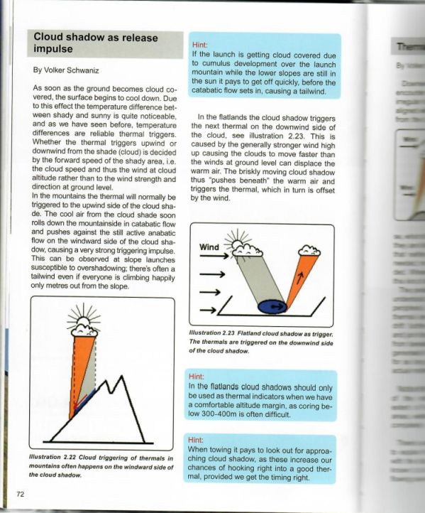
Other factors could be the cloud size, cloud height, and angle of the sun. At the west facing Woodstock launch in the afternoon, the cloud shadow would pass over launch before the cloud. That shade would cool the surface, causing, if not catabatic flow, at least some temporary dampening of the prevalent wind speed. This may be the mellow pre-thermal window at launch. Then, as the cloud comes closer and the cloud shadow passes, the sun-heated air just upwind of the cloud shade collides with the shadow-cooled air triggering the thermal. And that would feel like increased wind-speed as Larry described above. How do you like them apples?


Re: Weather/micrometeorology Woodstock question
If we are seeing effects at Woodstock that we don't see at our other mountain sites then the 'standard' explanations aren't telling us why Woodstock is unique. One thing that makes Woodstock unique is the evenly spaced lines of the Blue Ridge mountains immediately to the west.
The next time you take a commercial flight out of Dulles try peeking out the window at the cloud cover over the Blue Ridge mountains. You will often find that the clouds are lined up in nice neat corduroy wave lines. The prevailing NW winds will carry this undulating air right into our launch. The interference between those waves and the local conditions should yield the result described in John's original email. His description of the periodic lightening and darkening of the clouds is a good indicator provided that he is describing widespread conditions rather than an individual cumulus cloud passing overhead.
I think the interference pattern from this wave effect explains a lot of what we see at Woodstock that we don't see elsewhere.
Dan